Category Archives: Smap Release

Release announcements for Smap

Smap Version 14.01 Task Management

Announcing the release of Smap Evaluation Tools Server version 14.01.  This release includes

  • Task management: the ability to filter the surveys that are used as locations for new tasks
  • Task management: Printing of task allocations across multiple pages
  • Support for Internet Explorer 10+ as the browser
  • Improved reporting of errors when uploading templates

Task Management

Task Filtering

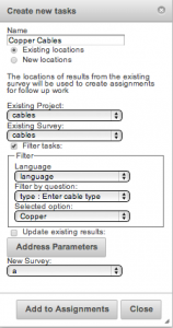
When you create new tasks from an existing survey you can now specify a filter on one of the questions in the existing survey.  Only survey locations that match that filter will be added to the new task group. Select the checkbox called “Filter tasks” to enable filtering.

tm1

Task Filtering


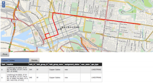
In the following example the previous survey recorded the paths of various cable types including copper and fibre.  However for the new task I only wanted the surveyor to go to the cables of type copper so I enabled filtering and selected the option of “copper”

tm2

Tasks filtered by cable type of copper

Printing Task Sheets

When you select the “Print” button to print a task sheet the tasks are now shown on more than one page.  This attached PDF shows this. Note the address parameters that have been added to help locate the location of each task.  In this case these include the age, ethnicity and a picture.


Smap Server version 13.12 with Time Series Analysis

Announcing the release of Smap Evaluation Tools Server version 13.12. The time series analysis functionality in this release has been funded by the Speed Evidence project. This is to assist in the long term response to Typhoon Haiyan.

New functionality

  1. Time Series Analysis.  Showing trends over time using graphs, maps and tables in the analysis module.
  2. Server side calculations.  There are only two functions available at the moment; area of a polygon and length of a line or the perimeter of a polygon.  However other functions could be added such as the calculation of Z-score anthropometric indicators.
  3. Export of attributes from parent forms to shape files.  If you select a child form containing a geometry and export to a shape file then all the attributes of the parent (up to the maximum of 255) will also be exported.
  4. Specification of default language.  The default language to show on the phone can now be specified by selecting “view/edit” link next to the survey name on the template management page.
  5. Support for Internet Explorer has been improved however it is still not supported, that is I haven’t tested this release against IE.

Availability

Hosted servers will be progressively updated over the next week or so.  The download for this release will be available by the 19th of January.


Release of Smap Shapefiles Export

Announcing the release Smap Evaluation Tools Server version 13.10. New functionality includes:

  1. Exporting surveys to ESRI shapefiles.
  2. Administration and analysis screens are a bit more mobile phone friendly.  With the this release you should be able to create and view analysis panels on your mobile phone now.  However this is work in progress.
  3. Surveys that have been blocked will no longer be available for download.  Submission of results from these surveys will continue to be prevented until the survey is un-blocked.
  4. Incomplete surveys are no longer included in results automatically.  These can be uploaded from the phones but they will be marked as “bad” surveys with a reason of “incomplete” by default.

Exporting Shapefiles

Individual forms within a survey can be exported as shapefiles and then imported into a GIS such as ESRI.

The Smap Server now supports exporting to XLS, CSV, Openstreetmap as well as shapefiles.

Blocking Surveys

Installing

You can download the server tar file from here.


Release of Smap HTML / iPhone Evaluation Tools

Announcing Smap Evaluation Tools Server version 13.09.  New functionality includes:

  1. Support for completing surveys on a web browser. Browsers need to support HTML5 and can be on a laptop, iPhone, Android or Windows Mobile .
  2. Automatic dropping of duplicate surveys.  Previously the duplicate would have been marked as “bad” so that it did not appear in exported results or graphs however these duplicates could still be seen in table views.
  3. Calculate questions are now shown in the exported spreadsheet in their correct position relative to other questions in the survey.  So if you add a question to calculate the age in months after a date of birth question, then age in months will appear after DOB in the exported results.
  4. If you explicitly specify a “start time”, “end time” or IMEI question in your survey then these are no longer automatically added by Smap as well

WebForm Evaluation Tool

webform

Screen shot of web form in Chrome browser on a  Mac laptop

Features

  • Uses the open source Enketo forms engine
  • (Should) work in any HTML5 capable browser
  • GPS coordinates
  • Multi- choice and single select questions
  • Integer and text questions
  • Uploading of photographs (on some browsers, those with better HTML5 support)
  • Repeating groups
  • Relevance
  • Works offline and saves results for submission later when there is a network connection

Issues

The web forms feature is really a beta release so you can expect to find some issues.  Report any you find and we will try to get them fixed in the next release.  Known issues include:

  1. Some odk 1.4 functions that depend on javarosa do not work.  For example the new date time functions.
  2. Surveys that have images in their questions or options will not work with webForms
  3. Large surveys may be slow particularly when downloading or expanding a conditional group
  4. Safari on iPhone has some additional restrictions:
  • File uploads are not supported on Safari / iPhone
  • Expansion of conditional groups that are made relevant based on responses to prior questions do not work

Phone Browsers

iphone

Situation Assessment using Safari on an iPhone

android

Situation Assessment using Chrome on Android


Applications for the web forms feature

The ability to complete forms on web browsers adds a lot of flexibility to your data collection. For example it is now possible to send out an email or tweet with a link to a survey that the recipient can complete on their browser.

Installation

This is straightforward and very similar to previous installation.  Updated instructions are in the README file.  If you have an existing smap installation you should be able to just run the webformsInstall script to update the platform to support webForms (MySQL and PHP).  You can then deploy the updated application code as before.  Contact me if you have any issues.

If you are installing your own server you can get it from here.

Deployment onto Smap Managed Servers

I will progressively deploy this release onto the servers managed by Smap Consulting over the next few days.  However the ability to complete surveys using WebForms may not suit everyone.  Hence I will disable this functionality by default on each server unless you request that it be switched on.

Acknowledgements

Web Forms uses the excellent Enketo toolkit. This toolkit has been integrated into Smap by the following undergraduate students from RMIT who have done an excellent job.

  • HeeSien Ooi
  • Kar Ming Clement Kam
  • Kiman Sze
  • Mohamad Bahaa Maarouf
  • Shishir Chawla
  • Teck We Kee


Release of fieldTask v3.0

Announcing fieldTask version 3.0. This release includes the changes in the odkCollect 1.4 release (thanks to the ODK team) along with the ability to send partially completed forms back to the server. You can download version 3 from google play and from the smap development server. It will be deployed onto other servers as they get upgraded.

ft3

fieldTask v3.0 Home Screen

1) Change Location. [Provided by ODK 1.4] There is a new ‘placement-map’ appearance for location questions.  If you use this “appearance” setting on a question of type “geopoint” then your current location will be shown on a map and you can do a long press on the map to change the position that will be recorded. The meaning of the 4 icons on the map is:

        1. Exit map without saving location
        2. Save location and exit map
        3. Place marker at current location
        4. Zoom to marker

location placement

2) New functions for date processing. [Provided by ODK1.4] Refer to the survey editing guideline and the example xls template.

3) Improved styling for phones with Android 3+. These will show an action bar with icons for some of the menu options. On smaller phones only one or two of the icons will be shown, the other menu options are accessible though the menu button.

icons

Android 2.2 phone menu showing all the icons. Android 3+ phones will show some icons on title bar, remaining menu options will be text when accessed through menu.

4) Access to question responses within repeating groups. [Provided by ODK 1.4].  This allows you to create one repeating group to get all the names of people in a household, then in a second repeating group you can ask detailed questions about each member of the household and refer to the name recorded for that householder. Refer to survey editing guideline and the example xls template.

5) Ability to defer constraint and “required” validation to the end of the survey. [Provided by ODK 1.4]. This can be enabled in the settings.

6) Sending partially completed forms back to the server.  If you have to save a survey half way through because it cannot be completed you can optionally send those results to the server.  After selecting “submit finished data” from the menu, press the menu button again and select “change view”. This will have two options “Show Complete Forms” and “Show Complete and Incomplete Forms”.  If you select the second option you will be able to see the saved incomplete forms and send them back to the server.

There will be an update to the server released by the 18th of October that will mark these incomplete surveys as “bad” with a reason of “incomplete”.  Hence they will not be included in exported spreadsheets or graphs unless the analyst marks them as “good”. If it is critical for you not to allow incomplete forms to be sent until the server is updated to mark them as bad by default, then defer use of fieldTask 3.0 until after the 18th of October.

Announcement of Smap Release – July 2013

Yep we missed a release in June this release contains 2 months of changes. New Features:

  1. Exporting of surveys to Openstreetmaps.  Refer to http://blog.zarkman.eu/?p=310 for details.
  2. Block submission of new results.  On the template management screen you can block or unblock a survey by clicking the checkbox next to the survey name.  This could be used where you have completed a survey and are analysing the results, however additional results are being submitted by someone who is demonstrating or testing the survey tool.
  3. Reports can be accessed by external systems through a reporting API. Download from here.
  4.  Reports can be embedded in WordPress blogs (or any other container that support the oEmbed standard).
  5. The bounding box of the area covered by a report is now shown rather than just showing a point for the report.
  6. Maps can be included in reports.
  7. The text that describes a graph or map has been improved. The text for a map now describes all the layers on the map.
  8. Validation on loading of templates.  The converted database friendly question names are now checked for duplicates.  Hence if you had a question named hdm0.1 and another hdm0x1. Then these would be reported as duplicates and the template would not be loaded. The reason that they are duplicates is that characters that are not accepted by the database as column names are converted into “x”.
  9. The XLS file that was submitted as a survey template can be downloaded from the template management page.
  10. Survey templates can be downloaded as a PDF.  This feature uses the Links Codebook code from Nafundi which has been modified to be accessible via a web service rather than on the desktop.
  11. Assignments of tasks are shown in a table as well as on the map.

The July version of the Smap server can be downloaded from here.


Announcement of Smap Release – May 2013

This release contains mainly bug fixes and minor improvements.  There was one major bug related to the pooling of database connections. Fortunately this didn’t cause any problems on the hosted servers as I had not enabled pooling.  But if you installed the server yourself, where it is enabled by default,then you may have noticed some issues.  I strongly recommend that you upgrade to this latest release.  http://smap-suite.googlecode.com/files/smap_13_05_01.tgz

Other changes include:

  1. You can assign a task where the location is described as a polygon rather than just a point.

    Task Management

    A task with polygon location on the phone

  2. “Relevance” was not working on repeating groups. Now it does.
  3. I removed the Twitter panel from the dashboard.
  4. Audio files are played in the media player.  At least it works for AMR files.
  5. Address items can be added to a new task. These items are selectable from an existing survey.  Hence if you are doing follow up surveys you can include data from the original survey to guide the user to the right location.
  6. The addresses of tasks can be printed, and address items can be set to be barcodes.  Hence the enumerator can get the barcode from the address in order to link the new survey to the old survey.

Announcement of Smap Release – April 2013

Dashboard panels are now only viewable by the user that created them.  No more sharing!  The concept of sharing all dashboard panels worked reasonably well when a project team was working collaboratively on a project.  But there were still issues, for example when a team member wanted to do some experimentation with graphs.  However there were significant problems during workshops when 30 odd people were creating and deleting panels independently and the system was trying to keep all of the panels in sync.   So I came to the conclusion that no-sharing is better than sharing everything.   If anyone has any ideas on how to introduce some managed sharing back in to the dashboard panels let me know.

You can now specify address fields from the previous survey in follow up tasks.  See picture below:

tasks

fieldTask works a little differently.  The menu option “get new forms” now goes direct to the server.  If you want to delete forms or data from the phone you will need to select “delete forms” from the main menu.  

Other changes:

  • More informative error messages when uploading templates
  • Surveys can be set in settings to automatically upload when they have been completed (with odk1.3)
  • In settings you can specify the use of forward and next buttons instead of swiping (with odk1.3)
  • Vertices of polygon questions are now shown on map panels.  Apart from allowing the user to look at question responses on each point of the polygon the display of these points make it easier to find small polygons on the map.  (This one for Mark)
  • The usual assortment of bug fixes

Announcement of Smap Release – March 2013 (mini release)

This is a rare mid-month release to add some functionality that I want to demonstrate at the WV Regional Disaster Management Training conference in Delhi.  The principal changes are improvements to task management. 

tasks

New Features:

  1. Reports are now specific to projects rather than to organisations.
  2. Publishing of reports to email, facebook and twitter can now be turned on or off at the organisation level
  3. Reports can be posted to twitter
  4. New tasks can be created by clicking on a map
  5. Tasks are now at the project level so each project can have its own set of tasks
  6. Tasks can be deleted by selecting them on the map
  7. Cancelled tasks can be cleared so they no longer on the task administration screen
  8. Plus multiple bug fixes

Announcement of Smap Release – February 2013


The february release of Smap is out of development and undergoing pre-release testing.

New Features:

  1. Multi-projects.  A user with administrator privilege can now create a new project and assign users to that project.  This allows you to manage separation of projects on the same server.  A user will only see the survey templates and results for the projects that they are assigned.
  2. Pictures, videos and audio can be included as survey questions or options.  Any or all of these media types can be added, along with text, to help an enumerator in completing a survey.  This capability has been on the phone for a while as it is part of odkCollect.  However the ability to manage this media on the server is new.  (video)
  3. Publish reports to a Facebook group.  This extends the current ability to publish a report via email.  A menu option named “Discuss” has also been added to allow you to link to a new Facebook app from Smap Consulting, that summarises the discussions on the reports as a word cloud and shows the locations of reports on a map.  (video)
  4. Added ability to specify an export of data as XLS or CSV.  For XLS exports the following formatting is now applied:

  • Dates.  Formatted correctly for excel and always set to GMT.  To change the timezone in excel add the hours difference divided by 24.  You can now do calculations such as subtracting _start from _end to get the duration of the survey.
  • _device formatted as number so it does not show as scientific notation by default.
  • Links added to locations.  If you click on the link it will show on a map where the survey was completed.
  • Links added to pictures, video and audio.

Bugs Fixed

  1. Hourglasses were not always being shown when the system was busy
  2. Name of survey in monitor screen was not being shown.
  3. Could not filter by survey name in monitor screen.Burn Down Chart
  4. Running out of database connections under heavy load

This diagram is of the project burn down and is taken from Acunote, which is a great tool for managing Agile projects. The chart shows the rate of progress across the month and confirms that development was completed on time.  Of course any tasks that could not be done prior to the release date, and that could be moved, were simply put into the sprint for the March release.  Completing “on time” for an agile project is usually a given!