The November changes described in these release notes may also require fieldTask version 6.803 or later.
New Features
Read only surveys
It has become a common scenario for people to use survey forms to look up information on the server from fieldTask or WebForms and often no data needs to be recorded.
However every form, when it gets to the end, invites the user to “save and exit”. A record of data is then sent to the server taking up valuable communications bandwidth and space in the database.
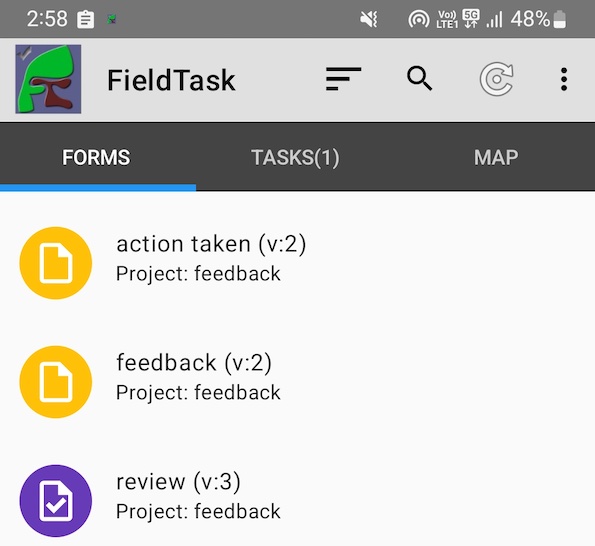
To improve the user experience we have added the option of making a form “Read Only”. When you get to the end of these the button just says “Exit” and no data is saved or sent to the server. These forms also appear with a purple icon in fieldTask and WebForms so it is immediately obvious to users that these are forms for looking up data and not for create a new record.
Documentation: https://www.smap.com.au/docs/read-only-surveys.html
Case Management
When a case is created there could be multiple surveys that can be used to complete that case. In fact any survey that is in the same bundle. This is fine if the user is working with the console, they can just select the survey required to complete the case. However on fieldTask we only want to show a single icon which is associated with a single survey form.
One option to solve this problem is to allow the survey to be specified when the case is assigned to a user. Probably we will end up going this way. However in this release cases replicated to fieldTask are now associated with the survey that last updated the record of data. Notify us if you need to be able to specify the survey used to complete the case.
Other
- There is a new parameter (geotextlength) which can be used to specify the maximum number of rows to display of the text answer for a geotrace, or geoshape question in fieldTask. For example: geotextlength=3
- The locking and releasing of records in the console has been debounced. Previously it was easy to click multiple times on these buttons which might cause odd error messages to be displayed.
- When you access geotrace or geoshape data from another survey using the pulldata() function, this is now formatted so that it will show in a geotrace or geoshape question. Previously it would have only been visible as text data.
- The user assigned to a case is now returned in a data API call. Look for the key value of “_assigned”.
Bug Fixes
- There were issues with the sorting of tasks in the fieldTask display
- There was an error in deleting cases in fieldTask that become unassigned
- pdfmapsource appearance was being set for every question opened in the online editor
- The simple filter on the analysis page did not allow preloads to be specified
- Using a select multiple question to specify multiple email addresses to be sent a notification was not working
- There was a recently reintroduced issue with loading CSV files that have a leading BOM character.