Automatic Deleting of Submitted Results
The server can be configured to request that the phone automatically delete successfully submitted surveys. This improves security on the phone as data is much less likely to fall into the wrong hands if, for instance, the phone is lost.
It is strongly recommended that automatic deletion be enabled. Currently it is off by default as I don’t want to surprise anyone with the changed behaviour. However in a future release automatic deletion may be made the default.
To enable automatic deletion edit your organisation and select “Delete submitted results from the phone”. Only an organisational administrator can do this. Automatic deletion currently will only happen when you use “Refresh” to submit your data.
Also if you configure the settings in fieldTask to send results automatically then the “refresh” method will be invoked, new form versions downloaded and submitted results deleted.
Recording GPS Trails
Recording of GPS trails for each user can be enabled by selecting a checkbox in the organisation dialog. Its the same dialog that can be used to specify automatic deletion of submitted results.
The path taken by the user will then be visible on the phone in the Maps tab, along with each location where they completed a survey. These survey locations are recorded even if there were no location questions in the survey form.
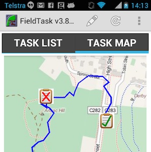
Map on Phone – One task has been rejected, one has been completed
When the fieldTask user presses the refresh button the GPS trail will be sent to the server along with any completed survey results.
The following video shows how the analyst or administrator can review the paths taken by the data collectors.
Privacy Issues
There are potential privacy issues with recording the path taken by the phone users. For this reason this function is off by default and has to be enabled on the server. It is advised that you contact the developers to discuss how you might use this feature and what additional privacy measures might need to be included prior to enabling. Current privacy controls are limited to:
- The user can switch off GPS
- The user can switch off recording by going to settings in fieldTask. However it will be re-enabled each time they do a refresh (assuming the server has be set to record the GPS trail)
- Recording of GPS set to “on” is shown in fieldTask settings
- The fieldTask map will show the trail of GPS points that will be sent to the server
Miscellaneous
- The obsolete Nutiteq libraries used for showing maps on fieldTask have been replaced by the MapBox API. This is a lot more pleasant to look at and also will support future functionality such as offline and custom maps.
- Added translations codes to the Analysis page. Thank you to Baba Sy and Telmo Peixinho for the French and Portugese translations.
- Reduced each row on the task list in fieldTask to only have two lines. The appearance is now less crowded. The forms version number has been put on the same line as the form name and abbreviated to (v: NN)
- Reporting of errors in template upload has been improved. These improvements include, checks for read only questions that are mandatory, checks for constraints that don’t refer to the current question, a reduction in unnecessary repetition when reporting on invalid functions.