
New Functionality
Download Custom/Offline Maps from Shared Resources
Custom maps can show information such as boundaries, or geo infrastructure, that is not available in the normal base maps. These maps can also be downloaded to FieldTask allowing them to be used offline, hence you will usually see them referred to as “Offline Maps”.
Before this release offline maps could be manually added in FieldTask from the “maps” settings page. Now you can enable the management of maps from the server for your organisation. The user will still be able to add offline maps manually.

Managing Offline Maps in Shared Resource
Offline maps can be uploaded In shared resources and then tagged with the projects that will access them. You can also delete offline maps that are no longer needed.
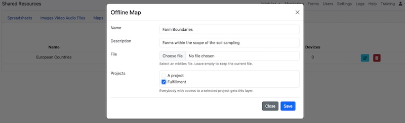
Downloading the Server Managed Offline Maps to a device
The next time the user presses “refresh” on their device any missing offline maps will be downloaded from the server. This happens automatically if the user is on a Wi-Fi network. If the download is interrupted then next time the Wi-Fi is available, the download will continue from where it left off.
If the user is on a metered network then they will need to confirm that they want to download the map as these can be up to 500MB in size. To do this they select the menu “Settings” then “Maps” then “Layers” from the server. They will then be asked if they want to proceed with downloading the map.
Once the map is downloaded it will be displayed over the top of the base map that you selected.
Creating offline maps
Raster maps can be created in QGIS. If you are just creating an offline version of an existing maps it is simple to do. If you want to create a map from a photograph then you will need to georeference it first which will require some additional steps. Generally raster offline maps are more useful. Vector maps can be created but they don’t currently have any syling information.
Two Factor Authentication
A user can add two factor authentication to protect their account. Use the menu under user profile to open a dialog that includes a QR code. This QR code can be scanned using any standard authenticator to add 2FA.
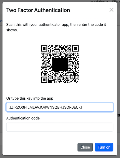
Multiple Server Keys
A new API keys dialog allows you to create multiple named keys and specify the expiry of each. Keys can be revoked from the dialog and the date and time the key was last used is also now shown.
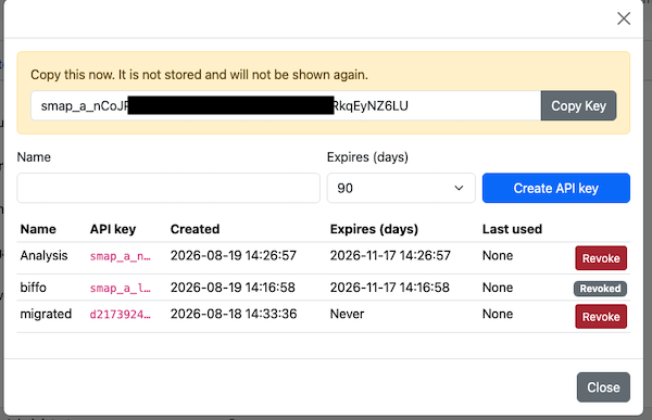
Other
- Added a report that lists users who have enterprise or organisational level permissions on the server. This report is available from the “Local Reports” menu on the form management page and requires the user to have at least organisational administration permissions to run it. Note this is new functionality but also a bug fix as this menu item previously existed but ran the same report as the “Organisational Structure” menu item.
- Performance Improvements. Replaced 4 database calls to get user information with 1. These were called at the beginning of every web service request so this change will reduce CPU and database resource usage. This change also adds caching for JDBC data source lookups.
- Deploy shared libraries to the tomcat shared class loader. This reduced the size of the Smap Server tar file by about 120MB after it had grown due to the larger libraries included in AWS SDK 2 and iText 8.
- Fixed a bug whereby the geo-point button was unresponsive in WebForms when it was run on a browser on a mobile device with a touch screen.
- Fixed a bug in which the open camera button was missing for an image question in WebForms run on a browser on a mobile device with a touch screen.
- Fixed a UX bug on the subscriptions page where after a successful subscription the button was still enabled to re-request that subscription.
- Fixed a bug in FieldTask where a long press on the maps tab would always select the nearest task even if the location of that task was not on the screen. The task has to be under the long press now.
- Performance improvements in Monitoring when the number of submissions is high (25 Million+).