Author Archives: Neil Penman

Version 23.05

It has been a busy few months of training which has contributed to a delay of 3 months since the last monthly update. However here at last is a new release for May.

New Features

A new Change password page

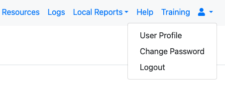
Previously a user clicked on the user profile menu item and then, in the dialog that popped up, they would select “Reset Password”. Now when you click on the user profile menu item you will see three sub menus.

Sub Menus under User Profile
  • “User Profile” takes you to the user profile dialog where you can change your current organisation, timezone, name etc.
  • “Change Password” takes you to the new Change Password page
  • Logout, logs you out of the application. This was previously also in the user profile dialog.

The change password page includes a button that will generate a random password for you. After you change your password and move to another page you will be asked to logon again. After you have done that your browser can remember, if you agree, the new password that you have used.

Improved role security

Previously if a survey had a role then an administrator, who also had that role, could add a new survey to the same bundle. This could be a problem if the role on the survey had column or row restrictions as the administrator could then by pass these restrictions. Now only an administrator who also has security manager privilege, can bundle new surveys to a survey that has roles. The security manager can then set any required row or column filtering on the new bundled survey.

Add the ability to force password expiry

The date a password is set is now recorded and the server owner can specify that all passwords older than that must be updated.

Console escalations

When automatically escalating a case to a new user after a console alert or record update you can now also send an email to someone notifying them of the escalation.

Another new feature is that a checkbox can be selected to send an email to the person who has been assigned, notifying them of their new case. This only works if the assigned user has an email specified in their profile.

Allow a form to explicitly set the key value

A user can specify that a survey form has a unique key and a key policy. Then records submitted with that key will be treated according to the key policy, merge, replace, discard or none (append).

However some times it is not possible to identify the components of the key when completing a survey. For example the key could be defined as:

${surname}-seq(surname)

So in the above case submissions with the same surname will not be considered as duplicates instead a unique number will be append. For example:

Smith-1
Jones-1
Smith-2

So to update these records you can use tasks and case management. But what if you wanted to do an ad-hoc update. This might occur if you go to a location and realise that there is new information to add to the record.

You can use the search() function in your survey form to download the key, such as “Jones-2”. This search function can use multiple questions such as name, age, address, gender to uniquely identify the record to be updated. If you now store the results of the search function in a question with name “_hrk” then that value will be used as the unique key on submission.

Other changes and bug fixes

  • Remove the warning that used to be shown when a survey form was created that had a group filled only with calculations.
  • In the console you can filter directly on the user name who submitted a record and the name of the user that the record is assigned to.
  • Clear the saved advanced query in the console if it causes an error.
  • Improve the efficiency of the uploading of submissions so that is uses less CPU and is faster.
  • Fix an issue with the API call to get a submissions list which would fail if GPS coordinates were malformed
  • Fix an issue with the preservation of a record’s unique key between record updates if that key inlcuded a seq() or serial() function.
  • Added additional event logging
  • Prevent a new organisation name from being specified that differs only in case. So we won’t now have organisations like Acme and acme and aCme registered on the SG server.
  • Fixed an issue that prevented initiating tasks from the console.
  • Allow administrators to move projects to one of their private organisations.
  • Remove the ability to move a user to new organisation Users should instead be granted access to organisations in their user settings by an administrator. They can then move themselves using the user profile dialog.
  • Fix issues when uploading empty data into a survey form from a file. This empty data was being set to text without characters, or in the case of a geopoint question, to a location of 0.0 0.0. The values will now be set to undefined as they would be if submitted from fieldTask.
  • Fix an issue where an non valid period to wait for a console alert could be set. This non valid period would stop processing of console alerts.
  • Fixed an error that prevented polygons from being used as default areas when accessed by the pulldata() function from a WebForm.
  • Fixed an issue with generating the default link to a survey form in a campaign email when the location of the link was not specified in the email content.
  • On the analysis page allow charts to group data by “note” type questions. This change recognizes that people are commonly setting values to note questions using dynamic defaults.
  • Add improved validation of XLSForms that have non valid headings on the choices worksheet.
  • Group outputs in the administration usage report by the survey identifier rather than the survey id. This means that replaced surveys will be considered the same survey in the report.
  • Add an option to the administration usage report to not include “All time” usage.
  • Upgraded multiple software libraries that had become out of date and had security issues flagged against them.
  • Fix an issue where the cache of a WebForm was not being updated when the survey definition had changed. This was occurring if the WebForm opened an existing record.
    • Increase the maximum number of records shown in a map, on the analysis page, to 10,000 from 1,000.

Version 23.02

New Features

The main change in this release is the upgrade of all pages to JQuery 3.5.1 and Bootstrap 4.5. Most pages were updated some time ago but some of the older, more complicated ones, had remained with the old version of these libraries.

The change you will notice is that the appearance of pages is more consistent. Those pages that used the older libraries such as the online editor should now have the same theme as Form Management.

The one exception to this improved consistency is the analysis page. JQuery has been updated, but it still uses jQuery-UI and not Bootstrap to set its appearance. Probably this page will never be converted to Bootstrap, but one day we will write a new Analysis page starting from scratch to replace it.

Other Changes

  • Added the “today” meta item to the list of meta items supported in the online editor.
  • Support added for the “user” meta item in WebForms.
  • Choice names can now have spaces. This only works with select_one questions which is the reason it was previously not allowed. Be carefully using this if you are going to change the question type to a select multiple.
  • Allow the user currently assigned to a case to be used as a filter in a search() function
  • Allow read only questions to be added to exports in predefined reports
  • Sanitise the HTML used in WebForms to restrict it to a limited set of permitted HTML elements
  • Removed automatic conversion of text to uppercase when using the grid format in WebForms

Version 23.01

Oh dear its 2023 already. A few holidays may have occasionally interrupted our development but we still have a January release.

New Features

Fingerprints

FieldTask can now capture fingerprints.

Setup

The fingerprints are captured using a fingerprint reader of which we currently support only one. The Mantra MFS100 from Mantratec which costs about USD80. This plugs into the USB port on an Android device. Assuming this port is USB-C then you will also need a USB-C to USB-A adapter.

MFS100 attached to a phone

It may be possible to support additional readers. Contact us with your requirements.

Some software is also needed to connect fieldTask to the physical reader. This is the Smap Fingerprint reader app. It can be downloaded from the server home page under the download menu. This app is an extension of the opensource Keppel app, the extension being to capture fingerprints as an image, Keppel only supports the ISO 19794-4 fingerprint template.

The lSO template can be used with Smap, it stores the fingerprint minutia in a text file, which is smaller than an image, however it is difficult to manually validate matches. Using images you can find matching records in the system that exceed a threshold of similarity and then visually inspect them to assess the accuracy of the match.

The form

Example form in Google Sheets.

For each fingerprint that you want to to capture create a question in your form. Set the question type and appearance as per the following table.

Fingerprint TypeQuestion TypeAppearance
Imageimageex:uk.ac.lshtm.keppel.android.SCAN(type=’image’)
ISO 19794-4textex:uk.ac.lshtm.keppel.android.SCAN(type=’image’)
Specifying questions to collect fingerprints

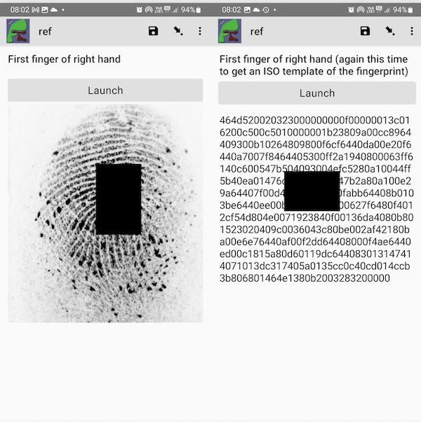
The resulting fingerprint and ISO template are shown below. The black square was added using an image editor to mark the data as a sample only.

Image and ISO fingerprints in FieldTask

Finding Matches

Only a very limited matching capability has been added in this release. This functionality will be increased according to need. On the console, if you select a record, a new button labeled “Links” will be shown. Click on this button to open a page that shows the image fingerprints and any records that match. The default minimum score required for a match is 40.0. You can change this score and press the search button to search again. If you click on the link to a matching record it will open the record in a web form.

Algorithm to identify matches

Smap is using an open source fingerprint matching tool called SourceAFIS. Commercial alternatives offer more accurate matching however being open source results in a more sustainable system. Organisations collecting fingerprints should also investigate using this system to collect fingerprints that can be used to train an Artificial Intelligence system to find matches.

Download Menu on Home Page

Previously we had an image on the home page that you could click on to download the fieldTask app. This was a “big button” to make it easier for users of mobile phones to interact with the web server. However browsers on phones handle menus well, so in this release there is now a download menu.

Accessing the download menu from a mobile phone

This menu includes the fieldTask and the fingerprint readers apps which can be downloaded onto an Android device. Smap uploader is still available for download to a laptop.

Other Changes

  • The “thread” value of a record is now included in the data API output. This contains the instanceid of the submission that created the record. Every time the record is updated it will get a new instanceid but the thread remains the same. It can be used to get the history of changes to a record.
  • The online editor now allows multiple columns from a CSV file to be specified as the. choice label for choices obtained using a search function. Previously this could only be specified using the spreadsheet editor.

Version 22.12

New Features

Highlighting of survey types on the survey admin page

Form Management Page with multiple survey types

An additional column, labeled “Type”, shows the survey type. This is left blank if the survey is a standard data collection survey. A colour highlight is also applied to help make the survey type stand out.

Survey TypeHighlight ColourDescription
OversightOrangeSurvey used in the console to update a record
Read OnlyPurpleSurvey that is used by people with mobile devices to view data from the server, but does not submit any results.
DataNoneStandard data collection survey
Types of Survey and their colour on the survey admin page

Assign a case from FieldTask

A case consists of a record of data and a survey form to update that record. Once a case is assigned to a user it will appear in FieldTask and in WebForms. The case can be updated multiple times until it is complete and no longer assigned.

In this release you can now assign a person to a case by selecting their name in a survey in FieldTask. For example in a policing app you may want to assign a particular detective to follow up a case from the field without requiring that to done as a back office function.

Notification to assign a person to a case using data from another survey

The survey that contains the assignee and the survey to be completed must either be the same or be in the same bundle. There must also be a key so that the record to be used in the case can be identified

Keys apply to bundles of surveys

Previously a unique key had to be specified for each individual survey. Multiple surveys combined into a single bundle could end up having different keys and key policies. This could cause problems as new entries from surveys without key policies would create duplicate records.

The obligation was on the survey designer to make sure each survey in the bundle had the same key, However now a common key is used across all bundles and only needs to be specified once.

When you select “Keys” in the File menu in the online editor, the case management page will be shown, you can then specify the common key for all the surveys in the bundle.

Other Changes

  • Cases are now shown on the WebForms page on the tasks tab.
  • Cases can be rejected in FieldTask and WebForms. The case will be set to not assigned. In WebForms the reject button is to the right of the button that opens the case. In FieldTask there is a menu option to the right of the case on the tasks tab. Select this then select the reject option. This feature requires FieldTask version 6.808.
  • WebForms will now mostly use the same colours as FieldTask to identify surveys and tasks. Yellow for data surveys, blue for tasks. The exception is for read only surveys which are coloured purple in fieldTask and grey in WebForms.
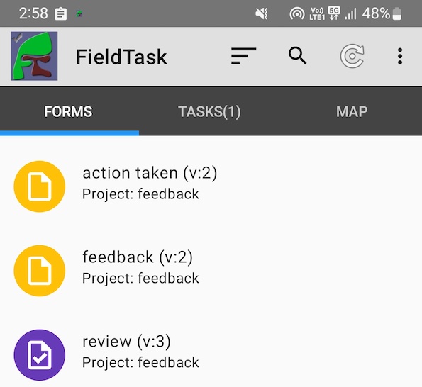
  • WebForms now includes an icon in the task list that indicates whether the list item is a task or a case. Cases are identified using an open folder icon and tasks using a file icon.
  • The “view” button in the console is now always enabled. This allows a person to view details of an unassigned record, including its history, without having to lock it first.
  • XLSForms can now include formula. Hence you could set choice names or labels using a formula and the value of that formula will be used in the survey.

Version 22.11

The November changes described in these release notes may also require fieldTask version 6.803 or later.

New Features

Read only surveys

It has become a common scenario for people to use survey forms to look up information on the server from fieldTask or WebForms and often no data needs to be recorded.

However every form, when it gets to the end, invites the user to “save and exit”. A record of data is then sent to the server taking up valuable communications bandwidth and space in the database.

To improve the user experience we have added the option of making a form “Read Only”. When you get to the end of these the button just says “Exit” and no data is saved or sent to the server. These forms also appear with a purple icon in fieldTask and WebForms so it is immediately obvious to users that these are forms for looking up data and not for create a new record.

Field Task showin a read only survey along with 2 data collection surveys

Documentation: https://www.smap.com.au/docs/read-only-surveys.html

Case Management

When a case is created there could be multiple surveys that can be used to complete that case. In fact any survey that is in the same bundle. This is fine if the user is working with the console, they can just select the survey required to complete the case. However on fieldTask we only want to show a single icon which is associated with a single survey form.

One option to solve this problem is to allow the survey to be specified when the case is assigned to a user. Probably we will end up going this way. However in this release cases replicated to fieldTask are now associated with the survey that last updated the record of data. Notify us if you need to be able to specify the survey used to complete the case.

Other

  • There is a new parameter (geotextlength) which can be used to specify the maximum number of rows to display of the text answer for a geotrace, or geoshape question in fieldTask. For example: geotextlength=3
  • The locking and releasing of records in the console has been debounced. Previously it was easy to click multiple times on these buttons which might cause odd error messages to be displayed.
  • When you access geotrace or geoshape data from another survey using the pulldata() function, this is now formatted so that it will show in a geotrace or geoshape question. Previously it would have only been visible as text data.
  • The user assigned to a case is now returned in a data API call. Look for the key value of “_assigned”.

Bug Fixes

  • There were issues with the sorting of tasks in the fieldTask display
  • There was an error in deleting cases in fieldTask that become unassigned
  • pdfmapsource appearance was being set for every question opened in the online editor
  • The simple filter on the analysis page did not allow preloads to be specified
  • Using a select multiple question to specify multiple email addresses to be sent a notification was not working
  • There was a recently reintroduced issue with loading CSV files that have a leading BOM character.

Version 22.10

New Features

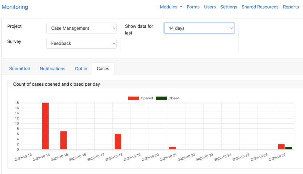
Case Monitoring tab

A tab has been added to the monitoring page to show the number of new cases created per day and the number closed. The period defaults to 7 days but can be extended to 30 days. Select a survey that has case management enabled to show data on the chart.

Monitoring of cases being opened and closed

Documentation is available here.

Archiving of Survey data

Commonly people are creating surveys to manage their day to day operations. These can become large with millions of rows and because they are accessed frquently this can also cause performance issues. Another common feature of this sort of usage is that only the last 12 months, or an even shorter period, of data might be frequently accessed.

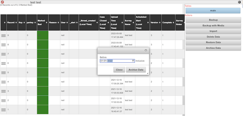
To support this use case we have added the ability to archive data older than a specified date into a new survey. This can be done from the analysis page using the aside. Refer to documentation here.

Archiving data submitted up until the 1st January 2022

Data older than the specified date will be moved into a new survey, identical to the current one with the archive date enclosed in square brackets and appended to its name. The survey with the archive data will be blocked by default.

That may be where you want to stop or you could move this survey to a project dedicated to backups so that it is out of the way or you could just delete it if the old data is of no use.

Minimum Password Strength

It has previously been possible to set minimum password strengths for the server or an organisation however to do this you would have needed to have organisational administration privilege. There is now a new tab on the users page called “Other Settings” that allows an administrator to set the minimum password strength for their organisation.

Other Changes

  • The appearance of the monitor page has been changed so that tabs are now used to separate different types of data.
  • Add a control to select “placement-map” as an appearance in the online editor for geotrace, geoshape and geocompound type questions.
  • Modify the chart view in the console to allow users to add charts. In the future it will be possible to add charts on question data however for the moment these charts still need to be related to case management.
  • Performance improvments to the console
  • Allow ampersands ‘&’ to be used in a choice value
  • Allow the source of a static map included in a PDF to be specified as an appearance setting on a question. The source can be google or mapbox.
  • When a survey is tested on the admin page that survey is now set as the default survey show that its results will show automatically in the console.
  • Removed the ability to forward a submission to another server.
  • Add a monthly report on events such as static map views.

Version 22.06

This release is focussed on improvements to case management. The changes have been requested specifically for an accountability system however they should be useful for any case management system that you implement.

New Features

Escalation / Assignment

Cases can be automatically assigned to a user or reassigned to a different user. The latter potentially being an “escalation”. The rules for an automatic escalation are specified in a notification and can be triggered by the updating of data in a case or a case alert (another new feature described below). For example you might create a notification that is triggered by the submission of a completed survey and that then “escalates” the new case to someone. In this case the escalation is just doing the initial assignment. However if an alert is triggered indicating that the case has not been closed within a specified time interval then this alert can also trigger a notification to escalate the case to a new user.

Completed Case

Completed cases are defined as a case that is not assigned to anyone and that has a status equal to the “final status” for the case. These will be hidden by default in the console. A case will enter the completed state automatically when its status is set to the specified value.

To enable “completed cases” use the online editor for a survey to select the tools menu and then Case Management Configuration. You can then specify the question that holds the status and the value that indicates that the case is complete.

Case Alerts

Alerts can be added to a survey bundle. These are triggered a specified period of time after the case is created if the case has not been closed. The alert can then be viewed in the console and used as a trigger to a notification to escalate, send an email or create a task.

Charts

Case Management Charts on the Console Chart Tab

There are currently 4 fixed charts that are related to case management.

  • Status. Frequency of each status among the current cases.
  • Assigned. Who has been assigned cases.
  • Alert. Frequency of alerts triggered by the cases.
  • Criticality. Frequency of each value in the criticality column.

The charts are on the chart tab of the console. They will use data from the current set of cases after filters have been applied. So if you have specified that only cases between two dates should be shown, the charts will only use that data.

Mobile Devices

A user who is assigned a case will see that case in the tasks tab of fieldTask. The case will remain on the device until either the user completes it or it is re-assigned to someone else.

Note the case is only downloaded if a final status has been specified for the bundle of surveys. That is if the case can be completed.

Cases are shown with a “folder” icon with a blue background if the case has not been modified on the device, once the case is modified it is shown with a purple background. However unlike tasks or other completed survey instances a modified case is always editable so the user can make multiple updates before synchronising.

Unmodified Case
Modified Case

The case will be labelled with the instance name of the record. If the instance name of the record is not set, then the key for the record will be used. Finally if that is not set the primary key of the record will be used to identify it.

Other Changes

  • Allow calculations to be used to create media file names in the media export
  • Allow setting of password strength requirements

Version 22.02

New Features

Improved Performance

The number of submissions processed by hosted server has continued to increase with a corresponding increase in the size of datasets that are being analysed and reported on. The average submission rate is nearly 15,000 per day and 11 Million forms have now been completed on our hosted servers.

To address the increasing load we have made some minor performance improvements and scheduled additional improvements for the next release.

Multiple PDF Templates For One Survey

Previously you could add a single PDF template to a survey using the settings dialog in the online editor. That template would then be used anytime a PDF of submitted survey results was generated. The new functionality is much more flexible. You can have multiple templates that you can select when generating the PDF and you can also select not to use a template.

The settings dialog no longer has the PDF Template loading function, nor can you download the template from there.

Instead PDF templates are accessed in the online editor from the menu “Tools” and then “Templates”.

PDF Templates page with 3 available templates

Templates loaded via the old settings approach will be found here along with any new templates that you load. Those old PDF templates cannot be disabled (set as not available), set as default or have a rule specified for when they should be automatically applied. If you want to use these new features you can download the template, delete the old one and reload on the templates page.

Templates can be set not available if you don’t want one to be used. One template can be set as the default.

Rules can be added to automatically select a template to be used in an email notification of submission results. These rules use the standard server expression syntax. For example:

${region} = 'region1'

Compound Question Type

This feature builds on the announcement in the previous release of a “pdf_field” question type that could be used to combine geopoint location questions into a single compound map or image.

Now by using a “geocompound” question type you can consolidate the data collection into a single question.

geocompound question type

Geocompound works like the geotrace type in that a line can be sketched out over a map. However points on the line can also be tagged with a marker. In this release there are 3 marker types; none, pit and fault. In a future release these will be specified as parameters.

Geocompound questions are supported in webforms. They can be edited after collection and can be applied to PDF exports in the same way as the pdf_field type.

Other

  • Added an option to webform settings to disable “Save as Draft” checkbox.
  • Add an option to survey settings to compress PDFs
  • Add support for an attribute “pdfshowimage”. This can be used with select questions that include an image with each choice. The image for the selected choice will then be shown in the exported PDF
  • Add support for an attribute “pdfstretch”. This can be used with image type questions and will cause the image to be resized to fit into the space allocated for it in the PDF. The default action, without this attribute, is to fit the image into the space while keeping the height and length in their original proportions
  • Make the default source of audio for an audio question be internal rather than an external audio app
  • Allow traffic light symbols in PDF exports to be “crossed out”. Allow labels to be added to traffic light symbols.

Version 21.11

Here is the November release of Smap. We did not release an update in October, although you may have noticed that the version number of some server installations said 21.10, but if you clicked on the link for changes it just took you back to the September changes. Unfortunately I never got around to creating the release notes so officially October never existed.

New Features

Specialised PDF components

There is a new question type “pdf_field” so you can specify specialised components to be included in a PDF report. Documentation is here. Currently two new components are available and they are intended for use in reporting faults in cables or pipelines. However now that the framework has been created, we can add additional components. Let the Smap team know if there is anything you would like.

Component 1 – Fault Image

This component is given the names of the questions that record, start of cable segment, end of cable segment and fault position. It then shows these in an image that includes the distance from the cable segment start to the first fault and the distance from the end of the cable segment to the second fault.

Component 2 – Fault Map

The input to this component is the same as the input to the image component but this time the information is shown on a map.

Background Report Generation

Just as the new PDF components are specialised, this new background report generation may not be useful for many organisations. However it has been added to help large organisations.

The first report that has been converted to background generation is the user usage report on the form management page, if your organisation has thousands of users and millions of submissions then this can take a long time and report generations for these large organisations have been failing.

Selecting a usage report on the form management page

Now once the report has been requested a message will be displayed saying that the report generation is in progress and the completed report can be found on the reports page.

To access reports select the menu “modules” and then “reports”. The reports generated for the last two weeks are shown here and can be downloaded by clicking on the report’s blue button. If the report is taking a while to complete you may see its status as “Pending” rather than “Complete”.

The previous functionality available on the reports page can be found under the tab “Public Reports”. This still allows you to define a report and then get the URL to that live data report that you can share with other people.

Allow webform links to tasks to be completed multiple times

Previously if you created a task as part of an email campaign then that task could only be completed once. However there are applications where you want a task, preloaded with some specific data, to be completed multiple times. For example if you have a barcode that links to a task and you want that task for that url to be preloaded with a venue location say. Documentation.

Other

  • The version of fieldTask used to synchronise with the server is now included in the user audit log. This also requires fieldTask version 6.515+. Documentation.

Bug Fixes

  • Survey forms that do not have any questions no longer cause an obscure error to be displayed when they are downloaded on to fieldTask. Instead when the user opens the survey on fieldTask they will see a helpful message stating that the form has no questions.
  • When getting an email address from survey data in order to send a notification, previously the name of the question was used in the data query instead of the column name of the question. If the question name contained characters that were not valid as table column names then this would not have worked.

Version 21.09

New Features

Lookup reference data using an expression

Using the pulldata() or lookup() function you can now specify an expression. For example the following pulldata calculation will get the average age of people older than the answer set in the “age” question. The reference data is taken from a csv file called “people”. More information can be found in the documentation.

if(${age} >= 0, pulldata('people', 'age', "cast(#{age} as integer) > ${age}", 'mean', 'eval'),'')

Consistent reference data support on FieldTask and WebForms

Well more consistent anyway, there are still a few idiosyncrasies as you move between fieldTask and webforms. So for example the new feature of using an expression to lookup reference data works in both fieldTask and WebForms.

Other

  • Links created for mailouts can now accept multiple submissions. To allow this select the checkbox “multiple submissions” when specifying your campaign.
  • User locations page
  • Template upload checks for missing end repeats